




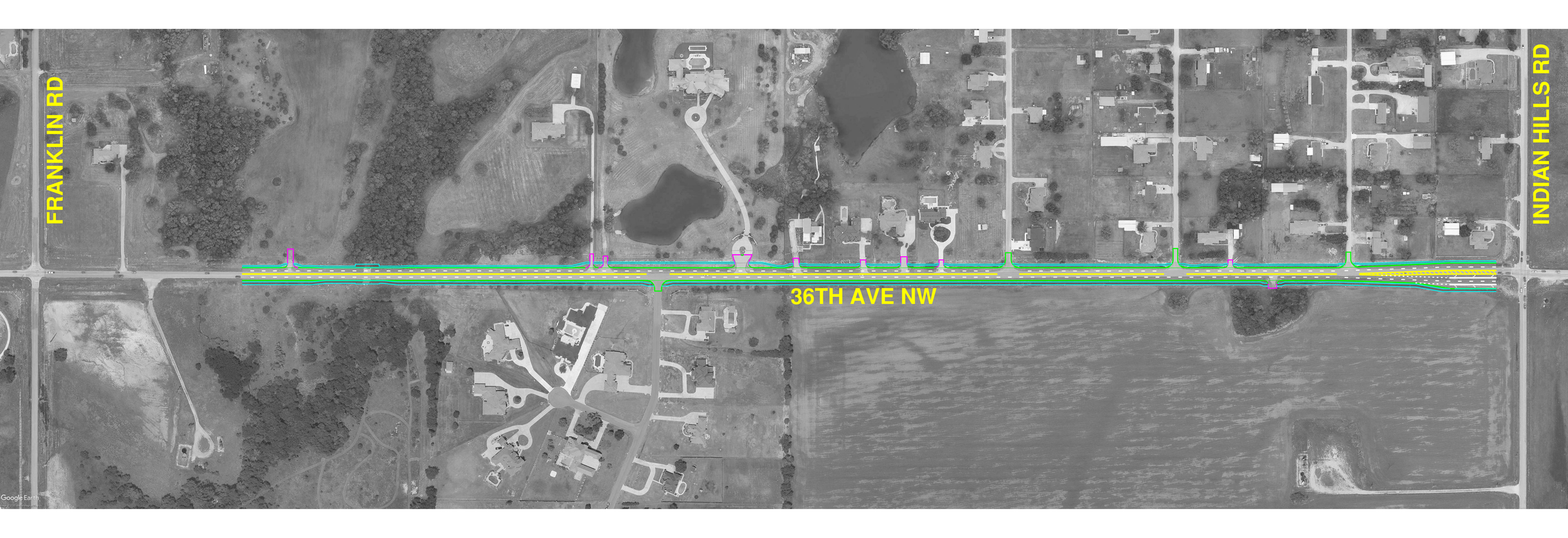
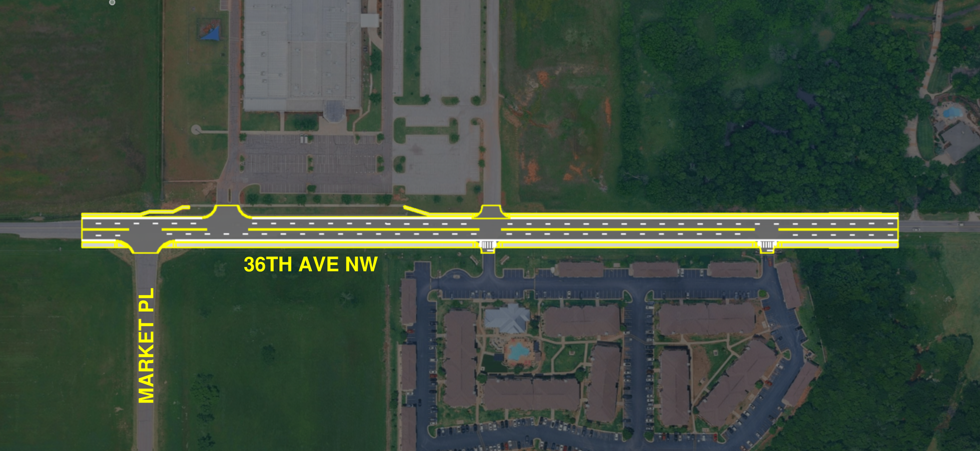
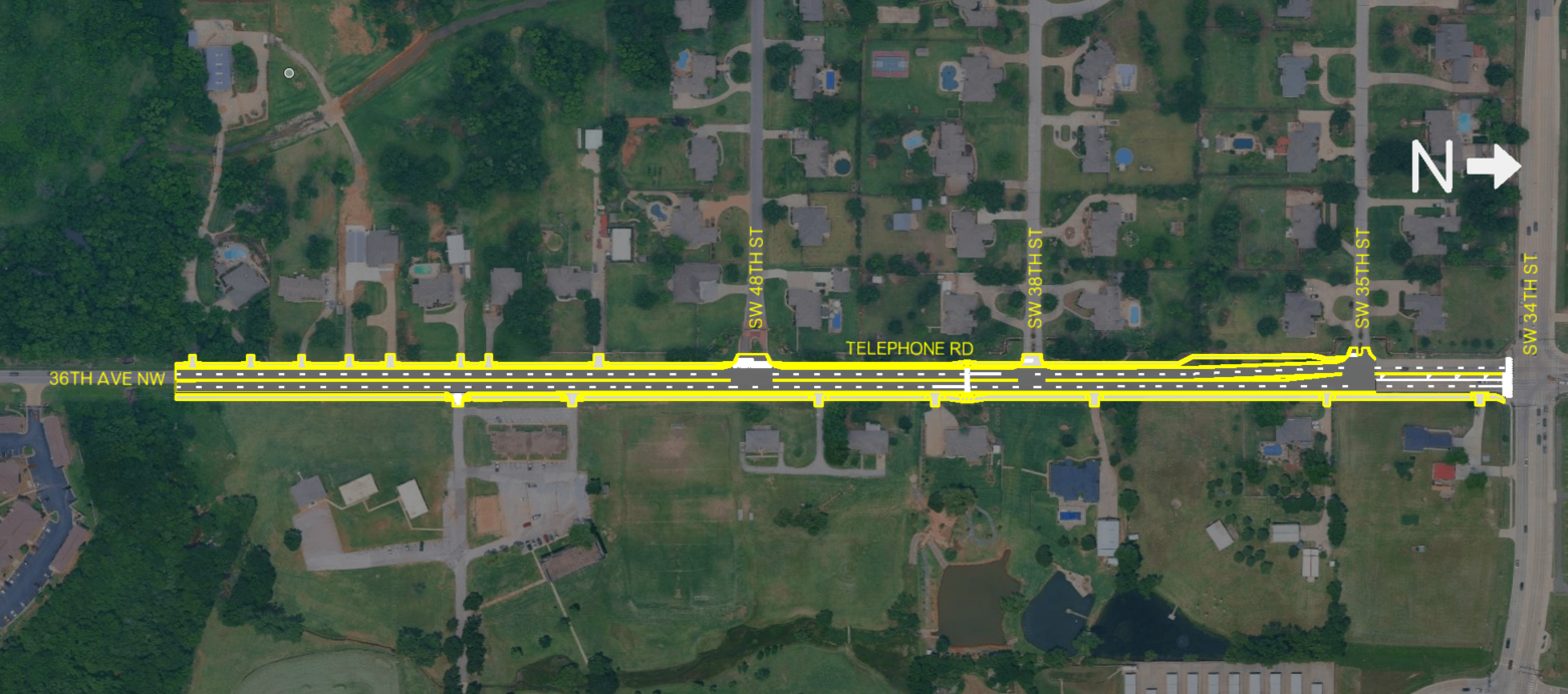
Use the left and right arrows to browse through the photo gallery. Click any photo to view a larger version in a new browser tab.
Project Background
In 2025, the Cities of Norman and Moore partnered to apply for funding through the U.S. Department of Transportation's Safe Streets and Roads for All (SS4A) Grant Program. The project was awarded the maximum grant of $25 million, allowing corridor improvements to move forward. The SS4A grant will pay up to 80% of the construction costs for the project and each city is responsible for paying the remaining match for their portion of the project.
Improvements include:
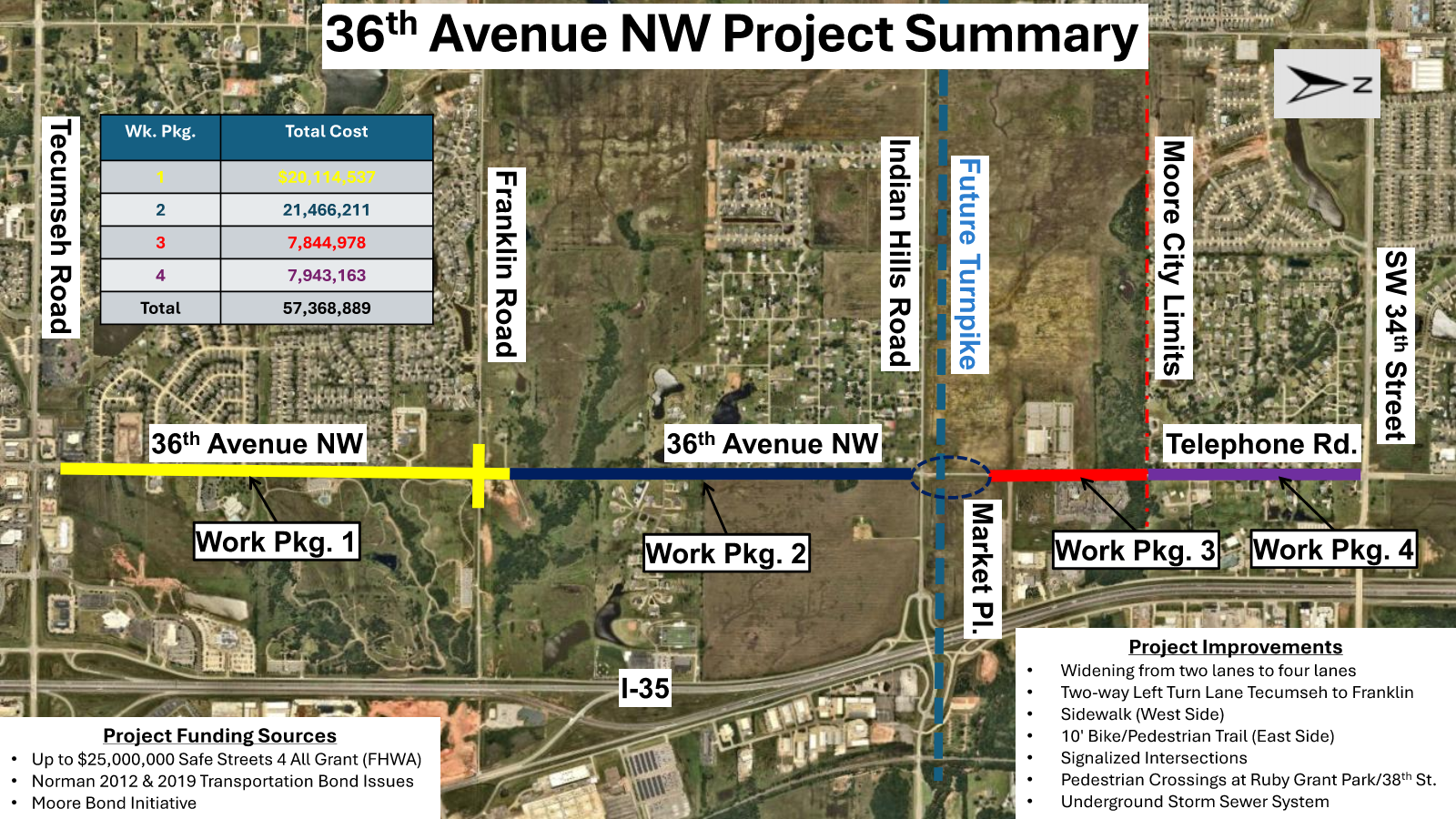
Widening from two lanes to four lanes from just north of Tecumseh Rd. in Norman to just south of 34th St. in Moore
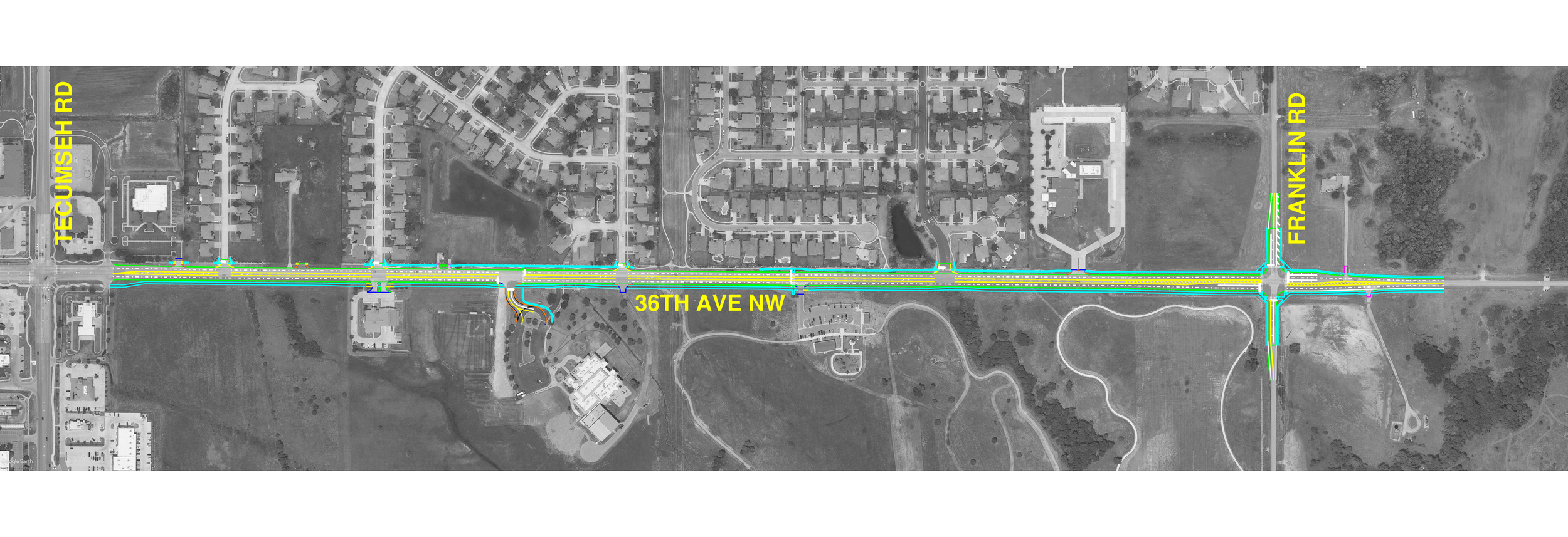
A two-way left turn lane between Tecumseh Rd. and Franklin Rd.
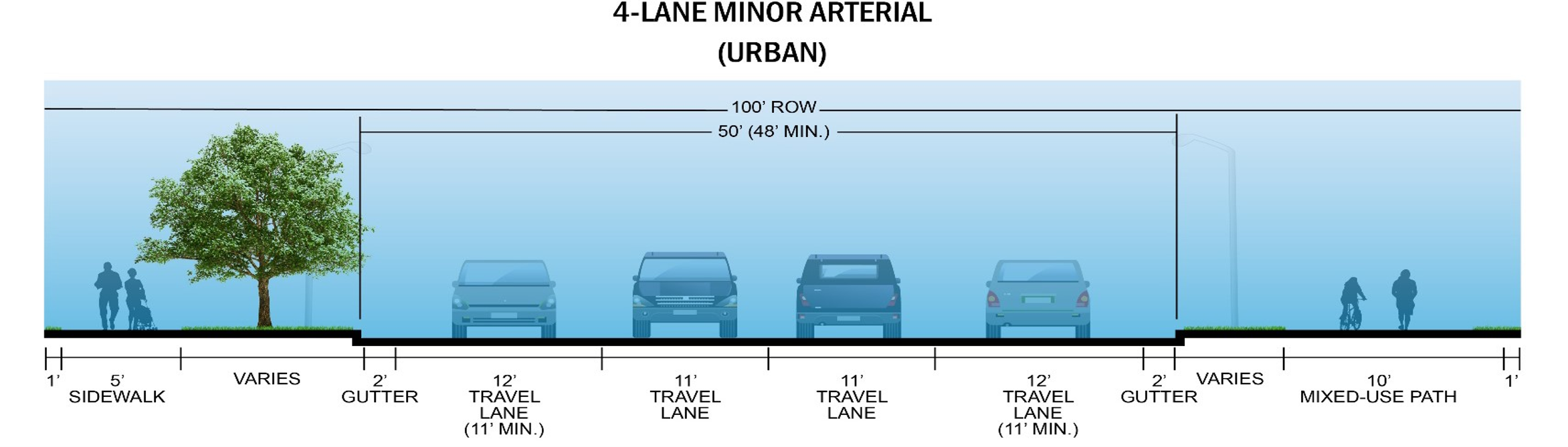
A sidewalk on the west side of the roadway for the full length of the project
A full length 10-foot-wide multimodal bike/pedestrian trail on the east side of the roadway that is part of a long-range plan to connect trails between Norman, Moore, and Oklahoma City
New signalized intersections, crosswalks, and pedestrian crossings
A new underground storm sewer system along the roadway to replace the current ditches and drainage culverts
Existing Conditions
The project corridor extends from W. Tecumseh Rd. in Norman north to S.W. 34th St. in Moore.
Today, the roadway varies significantly in width and design, creating inconsistent driving conditions. Some sections have four lanes with curbs, while much of the corridor narrows to two lanes with little or no shoulder. In one area, the roadway includes a center turn lane, and another section briefly widens to three lanes before narrowing again. As the corridor enters Moore, Telephone Rd. transitions back to a four-lane roadway.
Pedestrian facilities are also limited. Existing sidewalks are available only along portions of the corridor, including:
West side of 36th Ave. NW between W. Tecumseh Rd. and south of W. Franklin Rd.
The east side near All Saints Catholic School and Norman Fire Department Station 8
Project Purpose
The purpose of this project is to make travel along 36th Ave. NW and Telephone Rd. safer and more reliable. Improvements will increase roadway capacity, improve connections between Norman and Moore, and provide safer travel for drivers, pedestrians, bicyclists, transit users, and emergency vehicles.
Project Need
36th Ave. NW and Telephone Rd. are important north-south routes connecting the cities of Norman and Moore. The corridor serves neighborhoods, businesses, schools, parks, healthcare facilities, and emergency services. It also provides an alternate route when Interstate 35 is congested or closed.
As traffic has grown, the existing two-lane roadway can no longer safely accommodate the number of people who use it. The corridor has experienced increasing traffic congestion and collisions, highlighting the need for improvements.
Both Norman and Moore have widened sections of the roadway at each end of the corridor. This project will connect those improvements, creating a continuous, safer, and more efficient north-south route.
The project will also improve travel for pedestrians by adding a 5-foot-wide pedestrian sidewalk on the west side and a 10-foot-wide multi-use trail (extension of Legacy Trail) on the east.
Finally, the improved corridor will strengthen the region's transportation network by providing a reliable emergency and evacuation route west of I-35 during severe weather and other emergencies. It is also expected to support future regional transit service connecting Moore, Norman, and the Oklahoma City metro area.
Public Involvement
A public open house was held on August 18, 2026, from 6:00 to 8:00 p.m. at Quest Church, 6450 36th Ave. NW in Norman, OK.
Frequently Asked Questions (FAQs)
-
The project will reconstruct and improve 36th Ave. NW and Telephone Rd. from just north of Tecumseh Road in Norman to just south of 34th Street in Moore. Improvements include roadway widening, drainage upgrades, sidewalks, a 10-foot multimodal trail, and new pedestrian and traffic signals.
-
The project received a $25 million federal Safe Streets and Roads for All grant. City bond funds will provide the required local match. Current funding is expected to fully fund the project.
-
Work between Franklin Road and Indian Hills Road is expected to begin by the end of 2026. The remaining sections are expected to begin in early 2027, pending final federal funding agreements.
-
Construction is expected to take about two years, with the overall project not expected to exceed three years. Temporary pavement and traffic-control measures will be used to maintain open access for traffic as much as possible.
-
Yes. Access to dead-end streets will be maintained throughout construction. Temporary drives will be provided as needed.
-
The roadway will be primarily asphalt, with concrete curb and gutter and new underground storm sewer.
-
The existing roadway has inconsistent widths, limited shoulders, congestion, and safety concerns. Widening the corridor will improve capacity, safety, and connections between Norman and Moore.
-
Not as part of this project. The City of Norman will study the intersection after construction to determine whether it meets the warrants for signalization.
-
Yes. A 5-foot sidewalk will run along the west side, and a continuous 10-foot multimodal trail will run along the east side.
-
The project will replace existing surface drainage along Telephone Road with underground storm sewer and upgrade creek crossings. The new system will be designed to current drainage standards and updated rainfall data to better manage runoff and reduce localized flooding.
-
Yes. The posted speed limit along the improved 36th Avenue NW corridor will be reduced from 50 mph to 40 mph.
-
Yes. A High-Intensity Activated CrossWalK (HAWK) pedestrian signal will provide controlled pedestrian crossing at Ruby Grant Park and a signalized entrance at All Saints Catholic School will include an ADA-compliant crossing. The signalized intersections at Franklin Road and Indian Hills Road will also include ADA-compliant crossings.
-
Unlike a standard traffic light that changes on a timed loop, a HAWK signal remains completely dark for motorists when there is not a pedestrian waiting to cross. How it works:
1. At Rest: The lights are dark, and drivers flow normally.
2. Activation: A pedestrian pushes a button to request a cross.
3. Flashing Yellow: The overhead light flashes yellow to warn drivers to slow down.
4. Steady Yellow: The light turns solid yellow, telling drivers to prepare to stop.
5. Steady Red: The light turns solid red, requiring drivers to come to a complete stop so pedestrians can cross on a "Walk" signal.
6. Flashing Red: The light flashes red. Drivers must stop first but may then proceed with caution if the crosswalk is completely clear of pedestrians.
7. Return to Dark: The signals turn off completely once the crossing cycle ends
-
Mid-block safety: HAWK’s are often placed in busy areas between intersections where foot traffic is high, but a full traffic light is not needed.
Traffic efficiency: Since they stay dark unless triggered, a HAWK system does not stop vehicle traffic when no pedestrians are crossing.
Proven Safety: Studies show these beacons significantly reduce pedestrian-vehicle crashes compared to standard un-signalized crosswalks.
-
Residents can sign up for the City's Norman News List to receive project and construction updates.